Enhancing maize performance through precision phenotyping
phenomaize@mrizp.rs
Address: Slobodana Bajića 1,11185 Belgrade
Follow On :
PHENO_MaizE
What We Have Learned So Far: A Few Lessons from Our UAS-Based Field Mapping Training
Since none of the PHENO_MaizE team members had prior experience operating a drone, one of the project’s goals was to build expertise in UAS-based imaging for breeding trials. The first phase of training, conducted by licensed instructors, was completed in the first half of the last project year. The second part of the year focused on hands-on imaging of maize plots at different growth stages while varying mapping parameters. This provided additional flight practice, refined the crop mapping procedure, and helped establish a standardized imaging workflow for the next two years with a final goal to produce a high-quality orthomosaics and DEMs (Digital Elevation Models).
The following sections outline key factors influencing UAV-based data collection and processing. We believe this information could be useful for beginners in UAS-based imaging in crop science.
Methodology
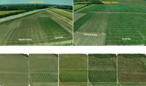
The project drone is DJI Mavic 3M, chosen for its compact, professional design suited for precision agriculture. It features a 20 MP RGB camera, a multispectral sensor (green, red, red edge, NIR), and an RTK module for centimeter-level accuracy. With a flight time of close to 40 minutes, it is operated via the DJI RC Pro Enterprise controller. Imaging was conducted at two locations, covering around 500 maize micro-plots. Eight imaging sessions took place from June to September to capture key growth stages. Trials at two sites with different sowing times helped mitigate weather-related risks. A computer with the following configuration was used for data processing: AMD Ryzen 7900X, 128 GB DDR5 RAM, and NVIDIA GeForce RTX 4060 Ti (16 GB).
Weather Conditions and Time of Day
While weather conditions cannot be controlled, imaging schedules can be adjusted to minimize issues. Fluctuating cloud cover during image acquisition caused variations in pixel values unrelated to genotype differences. During maize flowering in July, high-precision image alignment was challenging at 20m altitude, making orthomosaic generation difficult. However, images taken at 30m on the same dates did not face this issue due to reduced image detail. Imaging was conducted in the morning, creating shadows that interfered with stitching, emphasizing the importance of uniform lighting and midday imaging despite overheating risks.
Flight Altitude
Altitude affects resolution, imaging duration, and processing workload. Capturing one hectare at 15m, yielded 0.4 cm/px GSD, but also required 90–120 minutes, three battery swaps, and generated around 1,500 raw RGB images. Processing these images into final products (RGB orthomosaics and DEMs) took at least 5–6 hours using the project computer. Differences in orthomosaic sharpness suggested adjusting altitude based on maize growth stages to optimize image quality and efficiency. Thus, flight altitude should increase as maize plants grow taller in the field, and, for example, the altitude in the project maize field trials is set to range from 15 meters to 30 meters.
Ground Control Points (GCPs)
Six GCPs were placed at one location, but the RTK module provided centimeter-level accuracy even without them. Preliminary comparisons showed minor georeferencing differences between RTK-only and GCP-supported orthomosaics that could be crucial for minimizing data extraction difficulties and mistakes. Future trials will continue using GCPs with precise geodetic recordings to ensure alignment across different time points. Nevertheless, we consider a drone with an RTK module essential for this type of research, regardless of whether GCPs are used.
Image Overlapping
Overlap was fixed at 80% forward and 75% sideward, following best practices. While higher overlap improves stitching accuracy, it also increases flight time and data volume.
CONCLUSION
The training helped refine UAV-based imaging protocols and provided valuable insights into the challenges of field mapping. Key takeaways include the importance of flight altitude adjustments, consistent lighting conditions, and careful balance between image quality and data processing efficiency. These findings will guide future trials and may benefit others starting in UAS-based crop imaging.
Share the inspiration - spread the positivity to the world!