Enhancing maize performance through precision phenotyping
phenomaize@mrizp.rs
Address: Slobodana Bajića 1,11185 Belgrade
Follow On :
PHENO_MaizE
UAV Imaging in Controlled Airspace: A Practical Guide to Flight Permits in Serbia
UAV imaging in controlled airspace, whether for research or commercial purposes, requires navigating a range of legal and administrative procedures, especially when operating near airports. In Serbia, UAV regulations are shaped by several official legal documents, including the Air Transport Law, the Rulebook on Unmanned Aircraft, and the Regulation on Airspace Management, among others. These define the conditions under which drones can be flown, taking into account the aircraft’s category, location of use, and the specific purpose of the operation.
For the PHENO_MaizE project, compliance with all national regulations and the Project Environmental and Social Management Plan is essential. In its second year, the project includes intensive UAV mapping at two locations, both situated within controlled airspace near active airports. This proximity significantly increases the administrative complexity of preparing for and conducting UAV flights.
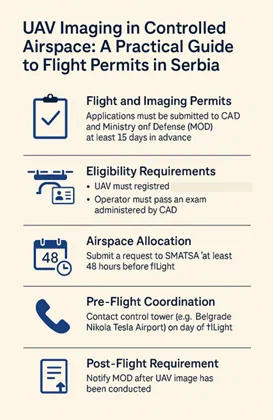
Permit Procedure for Flying Near Airports
To legally operate UAVs in such zones, teams must first obtain two key permits: one from the Civil Aviation Directorate (CAD) for flight operations, and one from the Ministry of Defense (MOD) for aerial imaging of Serbian territory. These applications must be submitted simultaneously, at least 15 days in advance, and are valid for up to 30 days, after which they need to be renewed if operations are ongoing.
Before permits can even be requested, there are two essential preconditions: the drone must be registered in the national Aircraft Register, and the operator must be certified, having passed the UAV pilot exam organized monthly by CAD. While the certification process is relatively simple, it is a non-negotiable prerequisite.
Once both permits are granted, a request must be submitted to SMATSA (Serbia and Montenegro Air Traffic Services Agency) to allocate the airspace for the desired date and location of the flight. This request must be made at least 48 hours before the flight, specifying the coordinates, time range, flight altitude, and the operator’s contact number. This step effectively reserves a portion of the sky, ensuring safe UAV operation without interference from other aircraft.
The most important information, contact details, and forms can be found here on the CAD website.
However, the process doesn’t end there. On the actual day of the flight, UAV imaging in controlled airspace requires operators to contact the Control Tower Shift Supervisor at the relevant airport—such as Belgrade Nikola Tesla Airport—to confirm that the reserved airspace is indeed clear and to receive final verbal clearance before take-off. Sometimes this happens immediately, but it can also be delayed depending on air traffic. During the flight, the operator must remain available by phone and be prepared to land the UAV immediately if a higher-priority aircraft needs to pass through the zone. After completing the UAV activity, it is mandatory to notify the tower so that the airspace can be released for other users.
Finally, the procedure includes one last requirement: after every UAV imaging in controlled airspace session, the Ministry of Defense must be notified with detailed information about the operation. Only after their approval can the collected imagery be legally used or published.
Our Experience and Tips
From our experience in PHENO_MaizE, operating UAVs in controlled airspace is demanding but absolutely feasible with good planning and communication. Our team faces additional challenges due to the frequency of flights—often two to four times a week—as well as the unpredictable nature of agricultural conditions, which makes it difficult to specify the exact flight dates in advance. To make this process more manageable, we recommend submitting airspace allocation requests with multiple possible dates (up to five consecutive days), which increases the likelihood of successfully conducting at least one flight in the intended window.
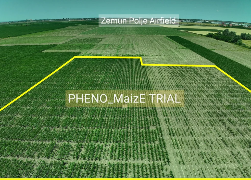
Moreover, one of our locations is less than a kilometer away from a small sports airport (Zemun Polje Airfield distance from our trials is shown in the photo above), which further increases the need for precise coordination during UAV imaging in controlled airspace. Based on our experience, we advise teams working in similar circumstances to designate a single person to handle all permit-related tasks and maintain proactive communication with CAD, SMATSA, and airport control authorities. Ultimately, understanding that airspace is a shared and limited resource helps foster a collaborative mindset—one that prioritizes safety and efficiency for everyone involved.
Share the inspiration - spread the positivity to the world!